(Navigon Mobile Navigator for iPhone Forum Review by cjvitek For more Forum Reviews, see the TiPb iPhone App Store Forum Review Index!)
MobileNavigator North America [$69.99 - iTunes link], by Navigon, is the second GPS TBT app I examined. This one requires you to download all the maps in advance (1.5 GB for the US version, 1.67 for the European version) so make sure you have space on your iPhone. The advantage of this is that you can get GPS directions even if you do not have an AT&T signal. In addition, the actual “routing” process seems a little faster since it is not downloading directions OTA.
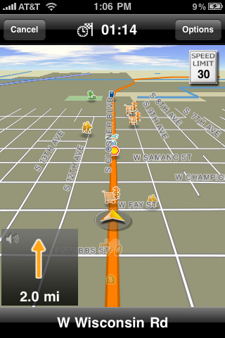
The map interface is very clean and flows very well, clearly showing direction and the upcoming street name. Unfortunately since the app doesn’t read the street name, you need to continually look at the app to see where to turn in areas when there are lots of streets next to each other. One nice feature is you can see POI on the map itself – not just a little dot or something, but an actual icon for the POI. When driving by a McDonalds, you can see the golden arches on the map. If the POI doesn’t have an logo, it just shows a general icon (gas station, food, etc).
To create a route, you can choose a variety of options in the route profile. These include fastest route, optimum (I believe for driving in cities), shortest, and scenic. You can also choose type of vehicle (including pedestrial), allow/avoid highways, toll roads, ferries, resident only streets, and HOV lates. I like the inclusion of a scenic route, although I am not sure the parameters. Will it take you ½ hour out of the way to see a nice waterfall? What about an hour?
Creating a route is very easy. The app has large buttons to press, and takes you through the step by step process (first state, then city, then street, etc). You can also choose to “take me home” where it will take you to your programmed home destination. At the bottom you can choose to select recent location, search your contacts, or select a favorite location.
Unfortunately you can’t specify roads that you prefer or want to avoid (like if you want to go a specific route, or travel by a specific town). In addition, sometimes the route choices seem…well…preposterous. When driving home yesterday, at one point the optimum route told me a certain way to go and get home by 8:07pm. The “shortest” route told me a similar route and got home by 8:08pm. The “fastest route” had me going to Corpus Christi, back down on a highway, and then backtracking – and getting home at 8:56pm. It made absolutely no sense what so ever.
When starting on the trip, I found the ETA to be generally reasonably accurate. An 11 hour, 630 mile trip was predicted initially as 12 hours. When looking at the map, you can tap the screen to see an overhead view, and also get a map summary. Unfortunately, there is no way to get a turn by turn summary of the whole trip.
Within the trip you have a lot of options. You have a speed option. The app comes with speed limits built in, which were accurate at least 90% of the time. You can program if you want the app to warn you if you are speeding (5 mph over, 10mph over, etc). Obviously you can’t rely on it, but it is a nice feature to have. In addition, you have the option of creating interim destination – basically a multi stop trip. This is one way to finagle choosing a specific route – just choose a city as an interim destination that is on the road you want to take! The app then tracks both trips, in terms of ETA and miles to go. You can also add a POI along the route (although I am not sure how far “off route” it searches – ½ mile? 1 mile?). You have a night map option and can also change your route profile (fastest to scenic, for example).
Searching for POIs is easy as well. First choose the location (nearby, a specific city, or statewide). You can preprogram three “auto” categories for quick searches as well – I chose gas, hotels, and food. Like other apps, you can’t define your search radius for “nearby”, but it looks to be about 5 miles or so. The POI library is somewhat lacking, however. While I can understand it for some out of the way hotels, there were some times that a McDonalds (or something similar) was mislabeled on the maps or couldn’t be found with a POI.
All in all, I found this to be a solid app, with lots of nice features added in. While the route choice was at times baffling, for the most part I had little to quibble about. The built in speeding warning is a nice feature to have, although you can’t rely on it because it is not always 100% accurate. The POI library was lacking somewhat, and I wasn’t really sure if I was missing some possible POIs along the way because of that. At $69 (on sale, normally $99) the app is not expensive, but still cheaper in the long run than a monthly fee system. Four out of five stars.
Pros:
- Easy POI lookup
- Maps on device
- Nice graphics and interface
- Lots of options for customizing
- Speed limit warnings!
Cons:
- POI database is lacking
- Doesn’t read street names
- Some routes are wildly inaccurate
TiPb Review Rating

[gallery link="file" columns="2"]

